
search
Istanbul ferry map
Bosphorus ferry map. Istanbul ferry map (Turkey) to print. Istanbul ferry map (Turkey) to download. Istanbul ferry allow you to move from Europe to Asia as its shown in istanbul ferry map. As with the metro, Istanbul residents use public boats/ferries – “vapur” in Turkish – every day and save considerable time by avoiding constant traffic jams on the two main bridges of the Bosphorus. By taking the Istanbul ferry, you will realize the vastness of Istanbul, it is also a good way to see the city from the water at a lower price. The main piers on the European side are Eminönü, Kabataş, Karaköy, and Besiktaş, and on the Asian side, Üsküdar and Kadıköy.
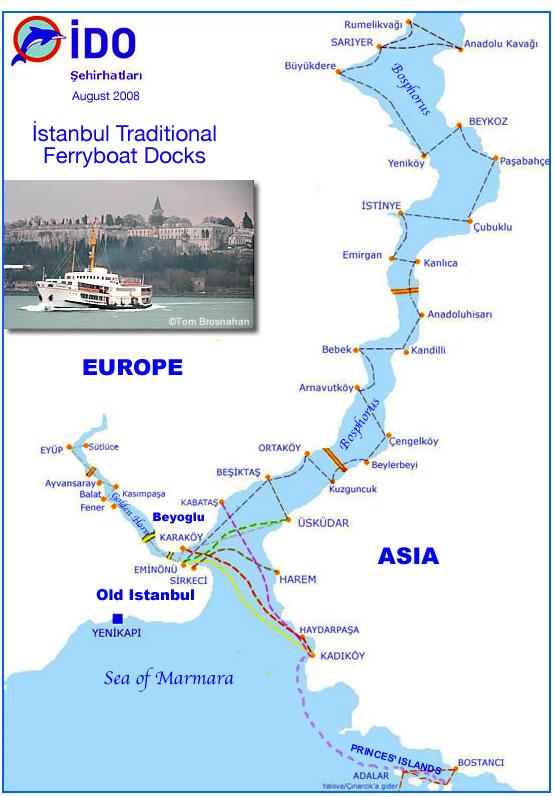
İDO (Istanbul Seabuses or istanbul ferry) runs a combination of all-passenger ferries and car-and-passenger ferries to ports on both sides of the Bosphorus, as far north as the Black Sea as its mentioned in istanbul ferry map. With additional destinations around the Sea of Marmara, İDO runs the largest municipal ferry operation in the world.
Istanbul ferries (Sehir Hatlari) are the most easiest, cheapest and the most pleasant way to travel up, down and across the Bosphorus as you can see in istanbul ferry map. With the Istanbul ferries you are able to travel from Europe to Asia and back. There are ten main ferry docks in Istanbul that include; Karakoy, Kabatas, Besiktas and five in Eminonu on the European side; Uskudar and Kadikoy on the Asian side. Ferries operate every 15-20 minutes from 07am. until 11pm.